The Utah Portal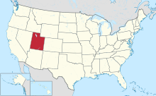  Utah (/ˈjuːtɑː/ YOO-tah, /ˈjuːtɔː/ YOO-taw; Navajo: Áshįįh Biiʼtó Hahoodzo) is a landlocked state in the Mountain West subregion of the Western United States. It borders Colorado to its east, Wyoming to its northeast, Idaho to its north, Arizona to its south, and Nevada to its west. Utah also touches a corner of New Mexico in the southeast. Of the fifty U.S. states, Utah is the 13th-largest by area; with a population over three million, it is the 30th-most-populous and 11th-least-densely populated. Urban development is mostly concentrated in two areas: the Wasatch Front in the north-central part of the state, which is home to roughly two-thirds of the population and includes the capital city, Salt Lake City; and Washington County in the southwest, with more than 180,000 residents. Most of the western half of Utah lies in the Great Basin. Utah has been inhabited for thousands of years by various indigenous groups such as the ancient Puebloans, Navajo, and Ute. The Spanish were the first Europeans to arrive in the mid-16th century, though the region's difficult geography and harsh climate made it a peripheral part of New Spain and later Mexico. Even while it was Mexican territory, many of Utah's earliest settlers were American, particularly Mormons fleeing marginalization and persecution from the United States via the Mormon Trail. Following the Mexican–American War in 1848, the region was annexed by the U.S., becoming part of the Utah Territory, which included what is now Colorado and Nevada. Disputes between the dominant Mormon community and the federal government delayed Utah's admission as a state; only after the outlawing of polygamy was it admitted in 1896 as the 45th. People from Utah are known as Utahns. Slightly over half of all Utahns are Mormons, the vast majority of whom are members of the Church of Jesus Christ of Latter-day Saints (LDS Church), which has its world headquarters in Salt Lake City; Utah is the only state where a majority of the population belongs to a single church. The LDS Church greatly influences Utahn culture, politics, and daily life, though since the 1990s the state has become more religiously diverse as well as secular. (Full article...) Entries here consist of Good and Featured articles, which meet a core set of high editorial standards.
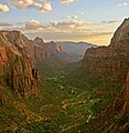
 The geology of the Zion and Kolob canyons area includes nine known exposed formations, all visible in Zion National Park in the U.S. state of Utah. Together, these formations represent about 150 million years of mostly Mesozoic-aged sedimentation in that part of North America. Part of a super-sequence of rock units called the Grand Staircase, the formations exposed in the Zion and Kolob area were deposited in several different environments that range from the warm shallow seas of the Kaibab and Moenkopi formations, streams and lakes of the Chinle, Moenave, and Kayenta formations to the large deserts of the Navajo and Temple Cap formations and dry near shore environments of the Carmel Formation. Subsequent uplift of the Colorado Plateau slowly raised these formations much higher than where they were deposited. This steepened the stream gradient of the ancestral rivers and other streams on the plateau. The faster-moving streams took advantage of uplift-created joints in the rocks to remove all Cenozoic-aged formations and cut gorges into the plateaus. Zion Canyon was cut by the North Fork of the Virgin River in this way. Lava flows and cinder cones covered parts of the area during the later part of this process. (Full article...)Selected image - The boundaries of the provisional State of Deseret as proposed in 1849 are shown in orange. The area of the Utah Territory as organized in 1859 is shaded in red.
June selected anniversaries
Selected biography - Alfred William McCune (June 11, 1849 – March 28, 1927) was an American railroad builder, mine operator, and politician from the state of Utah. Owner of several retail and construction businesses, he helped build the Montana Central Railway and a portion of the Utah Southern Railroad, founded the Utah and Pacific Railroad, and built railways in Peru, among other projects. He also owned many profitable mines in Canada, Montana, Peru, and Utah, including the Payne Mine—which paid the most dividends in the history of British Columbia. Late in life, he co-founded the Cerro de Pasco Investment Company, which became the largest copper investor in South America and the largest American investor in Peru until it was nationalized in 1974. He was one of Utah's first millionaires. He nearly became a U.S. Senator in 1899, but after being unable to receive a majority after numerous ballots and accusations of bribery, the state legislature adjourned without electing anyone to the seat. The Senate seat remained vacant for two years, and in 1901 another man was elected to the position. (Full article...)Selected article -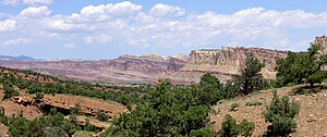 The exposed geology of the Capitol Reef area presents a record of mostly Mesozoic-aged sedimentation in an area of North America in and around Capitol Reef National Park, on the Colorado Plateau in southeastern Utah. Nearly 10,000 feet (3,000 m) of sedimentary strata are found in the Capitol Reef area, representing nearly 200 million years of geologic history of the south-central part of the U.S. state of Utah. These rocks range in age from Permian (as old as 270 million years old) to Cretaceous (as young as 80 million years old.) Rock layers in the area reveal ancient climates as varied as rivers and swamps (Chinle Formation), Sahara-like deserts (Navajo Sandstone), and shallow ocean (Mancos Shale). (Full article...)Did you know -
Selected panorama - Downtown Salt Lake City, Utah in 1913, looking east along 200 South from West Temple Street. To the far left is the Salt Lake Temple. The very white building right of the Temple is Hotel Utah, about one year old at the time. Just visible on the right side of the photo is the Salt Lake City and County Building clocktower. The Wasatch Mountains are in the background.
TopicsCategoriesGeneral imagesThe following are images from various Utah-related articles on Wikipedia.
State facts
State symbols:
Featured contentArticles:
Lists:
Pictures: Related portals
Lists
Related WikiProjectsNew articlesThis list was generated from these rules. Questions and feedback are always welcome! The search is being run daily with the most recent ~14 days of results. Note: Some articles may not be relevant to this project.
Rules | Match log | Results page (for watching) | Last updated: 2024-06-28 22:29 (UTC) Note: The list display can now be customized by each user. See List display personalization for details.
Things you can doAssociated WikimediaThe following Wikimedia Foundation sister projects provide more on this subject:
Discover Wikipedia using portals |


