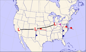
A Colorado low is a low-pressure area that forms in southeastern Colorado or northeastern New Mexico, typically in the winter. After forming, the system moves across the Great Plains.[1] Colorado lows can produce heavy wintry precipitation, and have a general east to northeast movement, impacting regions as far north as Winnipeg and as far east as the Atlantic coast. If upper-level conditions are right, the jet stream can push the low farther south, bringing wintry precipitation as far as Texas. When pushed this far south, the system is often referred to as a "blue norther".[citation needed] On the more typical track, a Colorado low can be similar to an Alberta clipper.[2] In the winter Colorado lows are responsible for a majority of the snow that the Midwest receives; however, summer systems can trigger long-lasting convective systems, including severe weather.[3] Spring and early summer Colorado low cyclogenesis can result in significant tornado outbreaks over the Great Plains and Midwest.
See also
References
- ^ National Weather Service. "Colorado Low". National Weather Service Glossary. Retrieved 21 October 2011.
- ^ American Meteorological Society. "Colorado low". Glossary of Meteorology. Archived from the original on 30 March 2012. Retrieved 21 October 2011.
- ^ Baker, D. James (2008). Weather: The Ultimate Book of Meteorological Events. Andrews McMeel Publishing. p. 34. ISBN 978-0-7407-6989-4.
External links


Hey There!!
Ya know how ya always wonder if those awesome recommendations you see on some websites might be written by the owners?
Well… This is one of those. Let me put your mind at ease and I’ll just come out and say it. Our products our awesome!!!
I hope everyone else feels the same way and posts their comments here 🙂
Enjoy every precious moment
Joe Zia