

No higher resolution available.
Northern_Mariana_Islands_map.gif (345 × 371 pixels, file size: 24 KB, MIME type: image/gif)
Summary
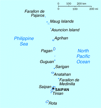
| Description | Map of the Northern Mariana Islands |
| Source | http://www.doi.gov/oia/Islandpages/cnmipage.htm |
| Author | United States Department of the Interior |
Licensing
| This image or media file contains material based on a work of a United States Department of the Interior employee, created as part of that person's official duties. As a work of the U.S. federal government, such work is in the public domain in the United States. See the Department of the Interior copyright policy for more information. |  |
File history
Click on a date/time to view the file as it appeared at that time.
| Date/Time | Thumbnail | Dimensions | User | Comment | |
|---|---|---|---|---|---|
| current | 03:17, 18 August 2010 | | 345 × 371 (24 KB) | Ras67 | cropped |
| 00:24, 17 May 2008 |  | 351 × 377 (25 KB) | Scanlan | {{Information |Description=Map of the Northern Mariana Islands |Source=http://www.doi.gov/oia/Islandpages/cnmipage.htm |Date= |Author=United States Department of the Interior |Permission= |other_versions= }} [[Category:Maps of the Northern Marian |
File usage
The following pages on the English Wikipedia use this file (pages on other projects are not listed):
Global file usage
The following other wikis use this file:
- Usage on af.wikipedia.org
- Usage on ar.wikipedia.org
- Usage on ast.wikipedia.org
- Usage on be-tarask.wikipedia.org
- Usage on bn.wikipedia.org
- Usage on ch.wikipedia.org
- Usage on cs.wikipedia.org
- Usage on cy.wikipedia.org
- Usage on da.wikipedia.org
- Usage on es.wikipedia.org
- Usage on fa.wikipedia.org
- Usage on fr.wikipedia.org
- Usage on he.wikipedia.org
- Usage on id.wikipedia.org
- Usage on incubator.wikimedia.org
- Usage on io.wikipedia.org
- Usage on ja.wikipedia.org
- Usage on ka.wikipedia.org
- Usage on ml.wikipedia.org
- Usage on mr.wikipedia.org
- Usage on pt.wikipedia.org
- Usage on ru.wikipedia.org
- Usage on ta.wikipedia.org
- Usage on to.wikipedia.org
- Usage on tr.wiktionary.org
- Usage on tt.wikipedia.org
- Usage on uk.wikipedia.org

Hey There!!
Ya know how ya always wonder if those awesome recommendations you see on some websites might be written by the owners?
Well… This is one of those. Let me put your mind at ease and I’ll just come out and say it. Our products our awesome!!!
I hope everyone else feels the same way and posts their comments here 🙂
Enjoy every precious moment
Joe Zia